Showing posts with label Mountain Madness. Show all posts

June 18, 2016

Mt. Daguldol (Mis)adventure

Mt. Daguldol (Mis)adventure

Meet King, my older sister who looks younger than me. 

My sister decided to climb because she’s turning 30...two years from now. As a very supportive younger sister I agreed to plan our climb. But she’s a bit annoying because she wanted a major climb and I don’t because I’m a pabebe climber- I don’t want to climb high and difficult-to-climb mountains. Before you start on me that it’s not that hard to climb 4/9 (and up) mountains I am telling you to stop. What works on you doesn’t really work on me. End of discussion. I just want to climb and be with nature and forget everything else. Even though I am not really sure on what I am trying to forget. Going back, since my sister didn’t really bother reading anything about Mt. Daguldol (672 MASL) I tried to read reviews and guides as much as I can and eventually came up with our own itinerary.

Syempre, sya ang bida. :D 

Since we were coming from Quezon City, we woke up at around 3 in the morning to catch the 4 am trip to San Juan, Batangas (via ALPS) at the Araneta Bus Terminal. Well, there were no buses bound for San Juan at the Araneta Bus Terminal (which is contrary to what the ALPS website claims). This is why I have trust issues. We asked the bus driver if there will be trips to San Juan and he just told us to ride their bus and they’ll drop us at Exit-I-can’t-remember where we can we ride a jeep to San Juan. So we took the bus that is bound for somewhere-i-am-not-familiar-with-as-long-as-i-get-to-be-in-batangas. Move on na lang tayo.

On the brighter side, the locals were very helpful to us giving us directions and what jeep to ride and so forth. We had three jeep rides before we reached Barangay Hugom and we arrived around 8 in the morning which is still early (I think). We registered and hired a guide who was somewhat old but has the strength of a horse. We started the trek right away after registering and my, I got tired easily. It's not really advisable to climb when you only had 2 hours of sleep and you're with an older sibling who keeps telling you "Ang bagal nyo naman."


Mt. Daguldol has a well established and relatively difficult trail. It rained the day before our climb so the trail was muddy and a bit challenging. 

Testing the chuck's limit.

The view isn’t as picturesque as compared to the other mountains I have climbed but it’s still a nice climb. We didn’t stay long at the peak and descended early because the weather wasn’t very cooperative. Well, it rained while we were descending! So we stopped and looked for a cover and ate chocolates until the rain stopped. This was my most "stressed out" climb just because rain.

At the summit.


I apologize because I can't help you with the itinerary. There are lots of them in the internet. Just have fun! :D


-goodnight-
donna

January 10, 2016

Mt. Tibig for Beginners :)

We climbed Mt. Tibig (563 MASL) two weeks after we climbed Mt. Tarak. One thing that I will always remember about Mt. Tibig is its deceitful difficulty level: it is 2/9 which means it’s an easy hike but it wasn’t, really. We usually laugh about this every time we discuss about the difficulty of the next mountain we’re going to climb. Pati pala difficulty level paasa (Even a mountain's difficulty gives false hopes these days).


Tibig
View from summit

Thinking it was an easy hike we decided to start the trek at 9 am but we woke up later than what was planned so we started at 10. One of our trek mates arrived in Lobo early, who came all the way from Laguna, and patiently waited an hour for us.

We were guided to the jump-off after registering our names at the Police Station. The road to jump off was so rough it needs a visit to the derma. We registered at the jump off and were given trekking poles (from tree branches) for free.

The trek starts with a steep assault and the trail is sandy and slippery and there’s nothing to hold on to. It was tough and I can’t count how many times we stopped to rest. Good thing our guide, Kuya Richard, is very patient with us but he’s quite shy. Unlike Ate Beth, our guide in Mt. Tarak, who shares stories while we climb he doesn’t talk at all unless you ask him but he’s nice and helpful.

Tired from the steep ascend, we were relieved when reached the well-known nipa hut. We rested for a while and bought Buko from the owner. From the hut, it will take around 30 minutes to reach the summit (or less if you’re fast).

Tibig

Tibig
View going to summit

Tibig

Tibig
Not the summit but almost there. :)

At the summit, the scenery is just beautiful – I was so happy that I ate all my baon.

Tibig
View from summit

Tibig
View from summit

Tibig
View from summit

Tibig
The island on the upper right is the Isla Verde.

Tibig
This ant is bigger than the normal size. But it doesn't bite.

Tibig
The view is simply beautiful.

Tibig

Going down, it was pretty challenging because the sandy trail can be slippery and dangerous. This time, I can't count how many times I almost fell down. But thanks to our guide who was there to help.

Itinerary:

0900H Register at Police Station
0930H Register at Jump-off
0945H Start trek
1130H Arrive at Nipa hut
Rest
1145H Start trek to summit
1215H Arrive at Summit
Lunch
Rest
1400H Start trek to Jump-off
1530H Arrive at Jump-off

Contact Person:

Gabino Boongaling - 0926 4916824/ 0919 4403941 (guide)
You may also ask him how to get to the jump-off (we went to Lobo via private car).


-goodnight-donna


December 14, 2015

Tarak Ridge: First Major Climb

Tarak Ridge: Adobo version

Mariveles
Tarak Ridge

This is one of my memorable climbs not just because it was my first major climb but I realized I can climb a mountain with major difficulty. Mt. Tarak  (1,130 MASL) has a difficulty of 4/9 and to be honest I wasn’t ready.  My last climb was back in 2012; I don’t exercise and I am usually sleep deprived. The night before our climb I slept at 12 midnight; I cooked adobo for our lunch and because internet.

I woke up at 3 in the morning to cook for breakfast. Yes, I am that nice. Hahaha! I was still sleepy but my nescafe 3in1 creamy white was doing its job well so I got that going for me. Our call time was 5 am but we left the house past 5. WOMEN, that’s why.

Our trek mates were getting impatient for waiting because we were an hour late. We arrived at Alas-asin at around 6 am. We paid the registration fee (which is left of the road) at the barangay hall then headed to Aling Kurding. You can walk from the highway or ride a tricycle to Aling Kurding’s. We chose the latter. Aling Kurding is an adorable old woman who guards Mt. Tarak. She’s been there for almost a hundred years yet she has the strength of a 30 year old woman. I’m just kidding.

With all seriousness, Aling Kurding lives at the foot of Mt. Tarak and that’s all that I know about her besides her being so nice. Her grand daughter, Ate Beth, was our guide that day. She has the strength of a horse. She has been climbing Tarak for a long time and what amazed me was she used slippers and she only brought 500 mL of water. Damn!

Anyway, let’s get back to Mt. Tarak. The trail has two parts: the easy at first which get harder and the hard which get extremely hard. The first part takes two hours and the latter takes one and a half to two. On the first part, the trail was easy but we walked through fallen trees and sometimes big rocks and giant roots. The moment you see talahib weeds the trail gets challenging: steep but manageable. Just be careful on holding on to plants because some are thorny.

Mariveles
When the going gets tough

After an hour of holding on to anything that looks sturdy we reached the Papaya River. It doesn’t offer a nice picturesque view but it’s a good place to rest – the water was refreshing and you can refill your water bottles here.

Mariveles
Papaya River

Mariveles
Papaya River

After our photo ops at Papaya River we decided to continue and boy it was hard! We have to stop every now and then because the trail, up to the ridge, was steep. You have to hold on to branches and roots of trees because you have nothing else. And every time I ask our guide, Ate Beth, how far the ridge is her response is always “One hour more.” She’s a joke.

Mariveles
View at Tarak Ridge

Mariveles
Tarak Summit

Well anyway, no matter how hard the climb was, when you get to the top it’s all worth it. The wounds I got from the thorns are worth it. The sprain didn’t matter because when you’re on top everything is just beautiful.

Itinerary:

0600H
Register at Barangay Hall
Ride tric to Aling Kurding
0630H
Arrive at Aling Kurding
0700H
Start trek to Papaya river
0900H
Arrive at Papaya river
Rest
1000H
Start trek to Tarak ridge
1200H
Arrive at Tarak Ridge
Rest and eat
1400H
Start trek to Papaya river
1530H
Arrive at Papaya river
Rest
1600H
Start trek to Aling Kurding
1800H
Arrive at Aling Kurding

How to get there:

For those coming from Metro Manila, ride a bus bound for Mariveles in Fivestar, Cubao. Look for Bataan Transit buses, their trips start at 1 am. Tell the bus driver that you’re going to climb Mt. Tarak. If he doesn’t know where that is, get off from the bus and go to Genesis. Kidding. J Tell them to drop you off at Alas-asin Barangay Hall.  

Major Expenses:
Guide – 900 (for the group)
Tric – 100/pax (roundtrip from main road to Aling Kurding)
Bus (from Cubao to Alas-asin) – Around 250-260/pax

Important reminder:

Unless you’re a pro, do get a guide. There are a number of mountaineers who get lost at Mt. Tarak (as per Ate Beth). Because Mt. Tarak is sometimes a troll.

Contact (Guide):
Ate Beth: 09495869556

-goodnight-
donna

November 2, 2015

I Don’t Usually Hike, But When I Do It’s The Highest in Cebu

I Don’t Usually Hike, But When I Do It’s The Highest in Cebu

Osmeña Peak

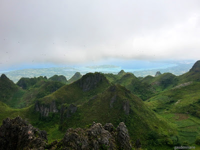
Welcome to Osmeña Peak – the most famous peak in Cebu, with exquisitely stunning view of pointed hills and of Cebu surrounded by the Cebu strait on the east, and yet not as challenging.

Osmeña Peak is just a 30-minute trek which is perfect for me and Alex because we don’t climb a lot. Reaching the summit might not be as tough as the other mountains but getting to the jump off point is a challenge.

We drove to the base via Kuya Loloy’s motorbike (he’s the tour guide I mentioned on Chasing Waterfalls with a Motorbike) and the unpaved and steep road going to the jump-off was the challenging part, we almost had an accident. We fell off from the motorbike after he loses control midway of the steep road. At least we only got minor bruises. 

Worth the minor bruises. 

Just awesome. 

That's how easy the trek is; I was only wearing slippers.

How to get there:

If you're already in Cebu:

-Hire a guide/driver (so someone could hold your things for you). Here’s our guide’s number (09254805221).

-Meet the guide/driver in Dalaguete (pronounced as Dalagit) town proper.  How to get to Dalaguete? Take a bus at South Bus Terminal bound for Oslob. Tell the bus driver you’re getting off at the town proper of Dalaguete . Or you could just ask Kuya Loloy, he'll call you. :D

*NOTE:
There is no entrance fee at Osmeña Peak; you just have to sign at their log book.

Bring a bottle of water (around 1 L). 


You could trek Osmeña Peak and chase waterfalls in one day. Just ask Kuya Loloy. :)


goodnight - donna

June 27, 2014

The Sleeping Giant

Brief History
Mt. Pinatubo is an active volcano located at the mountain ranges bordering Pampanga, Tarlac and Zambales. Its eruption in June 15, 1991 is the second largest volcanic eruption of the 20th century affecting not just the country but the weather around the globe. 


The peak of the volcano was wiped out and this resulted to a depression, the caldera, which is 2.5 km wide; the volcano has been quiet since its eruption. 

Monsoon rains filled the caldera with water thus forming a lake, the Lake Pinatubo which attracted a lot of tourists.

Getting There

We hired two vans for our round trip transpo since there were 18 of us; travel time from Mariveles, Bataan to the base camp (Sta. Juliana Capas, Tarlac) is around 2 hours. 

The Trek

We transferred to a 4x4 wheel drive upon arriving at the base camp. On our way to the jump off point, the photos were taken using my ipod. 


The travel time from base camp to the jump-off point depends on the situation of the road. During our trip, one of the 4x4s was stuck and we have to wait so we can move on. 

Credits to FTuyay
The 7 km trek starts at the jump off station.

Credits to FTuyay
Our guide (yellow shirt) who walks too fast (we were the first in our group to reach the crater). But this doesn’t mean you can’t rest, you can always inform your guide to stop/walk slow if you’re tired. As for me, I was very excited to reach the crater that's why. 


Credits to SDimaapi

One kilometer to the crater is a rest station/spring water refill station (I didn’t know that there’s a refilling station, I brought around 3L of bottled water which is kinda heavy.)


Almost there.
credits to SDimaapi

At the Mt. Pinatubo crater. 

I was very tired and my feet were feeling numb when we reached the crater but I felt relieved when I saw the lake. It was amazing that I developed a crush on it.

I can stare at this beauty for hours


During our visit, we had the chance to swim at the lake. However, a few months later swimming at the lake was banned.

Credits to FTuyay

There were no shower rooms/toilets at the crater so we just changed our clothes. I cleaned myself using wet tissues. If you want to bathe, there are shower rooms at the base camp.

Itinerary

· 3:00AM – 5:00 AM – Travel to Capas, Tarlac

· 5:00 AM – Breakfast at Mc Donalds Capas Junction

· 5:30 AM – 6:00 AM – Travel to base camp (Sta. JulianaCapas, Tarlac)

· 6:00 AM – Arrived at Base camp

· 6:30 AM – 8:00 AM – Travel to jump off point (4x4 wheel drive)

· 8:00 AM – Arrived at jump off point, trekking starts

· 10:00 AM – Rest station/spring water refill/decent C.R.

· 10:30 AM – Arrived at crater/lake

· 10:30 AM – 11:00 AM – Rest/Wait for others to arrive at the crater :)

· 11:00 AM – 1:30 PM – Enjoy the scenery/Take pictures/Lunch/Swim

· 1:30 PM – Pack up

· 2:00 PM – Trek back down to jump off point

· 4:00 PM – Arrived at jump off point

· 4:00 PM – 5:00 PM– Travel to back to base camp

· 5:30 – Travel back to Bataan

***We purchased a tour package at a discounted price from beeconomic (from Travel Save Tours). Inclusions are: ride to and from jump off point/base camp via 4x4 off-road vehicle, trip arrangements, and tour guide.

Important reminders:

Pack as light as possible. You are going to hike so just bring the essentials. Pinatubo has a very rough terrain and you’re going to cross rivers/streams on your way to the crater. I listed below the items you can bring: 

a) Cap/hat – There aren’t a lot of trees/shadeson your way to the crater

b) Sunscreen lotion – Due to climate change issues, put some on

c) Extra pair of clothes– Do I really need to mention why?

d) Extra pair of slippers – in case your shoes gave up which happened to one of us

e) Mask/Scarf – the road to jump off point can be very dusty

f) at least 1.5 L of water – You need to hydrate since you’re going to perspire a lot

g) Food - I get hungry easily so I brought enough food during our trek, no regrets

h) First Aid Kit – so what does your first aid kit should consist of? I think these would be enough: band aid, betadine, alcohol and salonpas. Unless you can carry the complete set for first aid kit up the summit.

i) Wet tissue

Trekking Outfit


Light shirt and arm sleeves cover/sweater

Shorts or leggings/trekking pants

Comfortable/Durable shoes

Others:

· Have enough sleep the night before your trek. You don’t want to faint on your way to the crater.

· Don’t skip your breakfast on the day of your trek, you’ll need the energy.

· Observe cleanliness. Don’t leave your trash anywhere, put it in a plastic and throw it to the nearest trash can. If there’s none, put it in your bag and dispose it when you get home.

· Follow the regulations at the lake. Swimming has been banned, so don’t swim. Besides, Pinatubo is a volcano not a beach.

· Hike Pinatubo only when the weather is good. Do not hike when it’s raining.

· Always keep in mind “Safety First”.